Image via Wikipedia
I’d like to take this opportunity to welcome you all to the Ozarks of northwest Arkansas. If you’ve never been here and want to check out the hiking and backpacking in these parts, you’re in for a very memorable experience. To those of you who have put down some trail around here, you know just what I’m talking about.
The Ozarks is a great place for day hikes as well as for multi-day backcountry excursions. What few people know, though, is that there is a thru-hike of about 233 miles that starts about an hour’s drive southwest of Harrison, Arkansas. Yes, it’s a little-known and well-kept secret.
Now, if you’re grabbing your maps and looking for this trail, you’ll find yourself wondering why your map doesn’t show it. The simple truth is that about 200 miles of this trail is comprised of two maintained trails that you can find on maps. However, those trails are linked by unmarked horse trail that you won’t find on any map. The two maintained trails are the Ozark Highlands Trail (OHT) and the Buffalo River Trail (BRT), and it is the Boxley trailhead to the BRT that lies about an hour to the southwest of Harrison.
You can find the Boxley trailhead if you travel south on highway 43 out of Harrison. It’s a drive that gets increasingly scenic as you head into Newton county and wind through Compton and on to Ponca. Soon after leaving Ponca, you’ll enter Boxley Valley where along with an occasional glimpse of the Buffalo River it is not uncommon to spot herds of elk. A few meandering miles into the valley is the intersection of highways 21 and 43, and it is there that 43 ends. Somewhere between two and three miles further south on 21 is the Boxley trailhead parking area on your right. Once you’ve parked your vehicle, head back across the highway and you will find the trail’s starting point.
Once on the trail, you’ll travel in a north, northeasterly direction through Buffalo River National Park back to Ponca. You’ll exit the Ponca area by hiking under the highway 74 bridge that crosses the Buffalo. In less than an hour the trail sneaks on above Steel Creek campground toward Kyles Landing, and after you’ve crossed the road going down into the Kyles campground, you have put behind you the toughest hiking on the BRT. Next on the agenda are the Erbie and Ozark campgrounds with the BRT culminating at Pruitt on highway 7.
Pruitt is the beginning of 30+ miles of trail that will test your skills as a backpacker, for it is this section of trail that is unmarked and subject to change by floods. This is a part of the Buffalo River where groups of horse riders do there thing, and it is by their efforts that the trail from Pruitt to Woolum exists.
To get yourself on this section of trail, you will have to leave Pruitt headed north on highway 7 and walk on across the bridge spanning the Buffalo. On your right just after you’ve completed the bridge crossing is a little parking area where you’ll find a trail and a road that both cut back to the south and down to Lower Pruitt Landing. The Landing is a stopping and starting point for folks canoeing the Buffalo. What you’ll be looking for once you’re there is the parking area for the Mill Creek Trail. As you’re standing there reading the information about the trail, look off to your right, and you’ll find the starting point for your unmarked journey. Follow that trail across Mill Creek north along the Buffalo until it crosses the river. Having crossed the river, your true adventure begins.
One thing to know about this section of trail is that, for the most part, it stays very close to the river, usually within 100 yards. Another important piece of information to have is that this is not a hike to undertake when the Buffalo’s kicking it up from heavy rains. As it is for sections of horse trail all along the Buffalo, so too it is for this — you will be crossing the river many, many times. So, a word to the wise, attempt this thru-hike only during relatively dry times.
Now, typically, when you leave dry land and cross the river, the trail on the other side is easy to find, but there are a couple points between Pruitt and Hasty (the first seven miles of trail) when this may not be true. If you encounter this problem, remember to keep your head on straight, search for a bit up and down the bank, and you’ll find the trail once again. Yes, this stretch of trail will test your skills as a navigator. If all goes well you will find navigable trail twisting back and forth past Carver and Mount Hersey and on to the link with the OHT at Woolum. Remember, this is unmarked trail that does not always readily present itself, so if you are not an experienced backpacker, this may not be a thru-hike for you.
From Woolum on, the trek is relatively easy. Just cross the river on the upstream side of Richland Creek, and you’ll be on the road that will take you off in a northwesterly direction for close to a mile before hooking left to the south through Richland Valley for several miles to the well-marked spot where the OHT heads into the woods leaving civilization behind.
The OHT leg of this journey takes you through country that differs in many ways from that which you experienced during the first 70+ miles of your trip. This is not to say that the scenery is any less splendid, for that it is not. This trail is well marked and maintained, and it has something for everyone regardless of your level of experience as a backpacker. You will cross numerous streams, partake of breath-taking vistas, and get to hike through some of the finest forests the Ozarks have to offer. Yes, as you hike along the OHT, you will be blessed with all sorts of awe-inspiring and challenging moments before you take those last steps to your destination at the Lake Ft. Smith State Park trailhead.
So, there you have it — a sketch of what is, at this time, the longest on-trail thru-hike in the Ozarks of northwest Arkansas. I will apologize, though, for one oversight. I am sorry for insinuating that your hike will end when you hit the Lake Ft. Smith trailhead. For all I know, you may be so psyched about what you have just been through for the past several days that you will be off on what will be the first leg of your yo-yo.
Till next time, I’ll catch you out on the trail — Dr. Brown
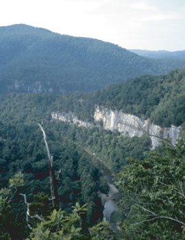
Great photo! Looks like a great place to hike.
It is certainly a great place to hike. The only problem is, I’m not sure where that photo came from. I’d hike it anyway. It sure looks like the Buffalo — somewhere.
Dr. Brown
I love to go on a hike or a nice walk with someone that is special to me. There is nothing like the great outdoors. I am behind what you are set out to do to help people with there issues. Good luck.
I agree about your observation that there is nothing like the great outdoors for helping clear the mind so we can address the issues confronting us. That is a lot of what psycHikes is about — getting out and walking and talking about our issues in a setting that is conducive to us relaxing. However, I realize that some folks are not all that comfortable with being outdoors, and that is one reason that I am dedicated to meeting people in a setting they find familiar and non-threatening, be it in their front room, their deck or porch, at a park or campground, or wherever. I’ve read that the number one factor associated with progress in psychotherapy, as noted by individuals who have been involved in that form of treatment, is the rapport they had with their therapist. Comfort with one’s setting helps foster that rapport, and so that is another reason I will bring the therapy to you. Say, thanks for your comment, and I hope you will feel free to post any other comments you may have. Make it a great day! Dr. Brown
Dr. Brown
I had a wonderful hike with a special person. We hiked to big bluff and it turned out to be a life saving moment for a couple of guys hiking. We happen to have extra water to give to these two hikers, they were out of water and just struggling to climb out. It was a warm day and water was something important to have plenty of. We felt real good about the hike for one we helped someone and another we got to spend sometime with someone who means alot. We took in some wonderful smell of rain and of course some picture’s. I think what you are wanting to do for others is wonderful, I know first hand how the outdoors can help one to feel free enough to help open the mind and talk about issues in ones life.
Sounds like you had a great hike on a couple of levels. Fortunately, we do not come across folks on the trail very often who are in need of help, but when we do it is certainly comforting to know our preparation for the journey has equipped us to assist someone for whom the tables have turned in an unpleasant, and perhaps, life-threatening direction. You got to help someone who was facing a possibly dangerous situation. I know from my own experience how good that feels. To top it off, you were fortunate enough to be able to share those circumstances with someone special to you. And, if that were not enough, there were nature’s sensations you and your friend got to enjoy. It doesn’t get any better than that. Thanks for sharing what turned out to be a very memorable experience! Hope to hear more from you. Dr. Brown